
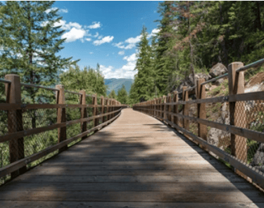
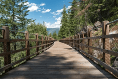
Top 10 Favorite Must-See Rail-Trails to Ride, Enjoy
Rail-trails rock! If you have walked or biked them some of them, then you know the fun of traveling through time on a trail bed that once held railroad tracks; of course, I am a train fan, so it's even more exciting to me picturing these old locomotives lumbering along as I walk or bike the trails.
Rail-trails are multipurpose trails -- for walking, cycling, and sometimes horseback riding -- that use abandoned railroad corridors. These trails often have the most amazing scenery traveling through forests, working farms, urban centers and small towns, across rivers and lakes, and through old tunnels and over bridges and trestles. Because railroad companies preferred easy grades for their locomotives pulling heavy loads, most rail-trails are flat or follow mostly gentle grades.
Rail-trails add value to our lives for their recreational benefits, but they also often serve to connect communities, sometimes spurring economic development. Many rail-trails also traverse through environmentally, culturally, and historically important areas.
More than 2,000 rail-trails exist around the country, with almost a thousand more under development... so it is hard to narrow that list down to the 10 must-see ones to visit as you plan your next travel adventures, but here goes...
Top 10 Rail-Trails in the U.S.
Katy Trail, Missouri.Hands down, one of the most wonderful and popular rail-trails, offering almost 240 miles of crushed-limestone surfaced trail from Clinton to St. Charles, just outside St. Louis -- the longest continuous rail-trail in the country. This trail is in the Rail-Trail Hall of Fame, is a designated Millennium Legacy Trail, and is part of the American Discovery Trail. The name comes from the railroad that once carried trains along the route: the Missouri-Kansas-Texas Railroad (MK&T), but known as the Katy. Half of the trail follows the Lewis & Clark path up the Missouri River, while rest travels through farmland and small communities. Near Rocheport, you can travel through a 243-foot tunnel built of stone and brick in 1893, while other towns feature railroad depots and old train cars. You'll find many towns along the route, many about 5 miles apart (with some even closer), offering food, lodging, services, and more.
Great Allegheny Passage (GAP) Trail, Pennsylvania and Maryland. This beautiful and historic 150-mile crushed limestone surfaced trail follows the routes of two railroads: from Pittsburg, PA, to Connellsville, PA, it follows the route of the Pittsburgh, McKeesport & Youghiogheny Railroad (the P-Mickey), which later became the Pittsburgh and Lake Erie Railroad, carrying coal and coke to the steel mills. From Connellsville, PA, to Cumberland, MD, the trail follows the route of the defunct Western Maryland Railroad -- and includes the beautiful Keystone Viaduct, a 910-foot long bridge that soars about 100 feet above the Casselman River. You'll also get to experience several tunnels, but the one most talk about is the Big Savage (Mountain) Tunnel, named after John Savage, an early surveyor who almost was a victim of cannibalism in 1736. Bonus for long riders: in Cumberland, MD, the GAP connects to the Chesapeake & Ohio Canal Towpath, which offers a direct path to Washington, D.C.
Island Line Trail, Vermont. Short, but packing a unique and spectacular punch, this 14-mile rail-trail begins in downtown Burlington, connecting the Burlington Bike Path, the Colchester Causeway, and the Allen Point Access Area. The south trailhead begins at Oakledge Park, but you can join the trail at several other locations. The trail follows the route of the Rutland Railroad, which used to transport dairy throughout the state, including a span almost all the way across Lake Champlain. The main feature of this trail is a 2.5-mile marble causeway that takes users onto the lake, where the trail stops abruptly. A seasonal bike ferry operates, connecting with South Hero, Grand Isle County, VT. With amazing views of Lake Champlain and New York's Adirondack Mountains, this trail is a must. Note: The trail's southern 7 miles are paved, while the northern half is crushed stone/gravel.
Bizz Johnson National Recreation Trail, California. This trail, the longest rail-trail in California at just above 25 miles, runs between Westwood, CA, and Susanville, CA, in Lassen County, and is named for former congressional representative Harold T. "Bizz" Johnson, who was instrumental in helping convert this route of the old Fernley and Lassen Railroad line -- used for hauling logs and milled lumber to and from the old Westwood Mill -- to a rail-trail for recreational use. The trail, which offers beautiful views of the Sierra Nevada Mountains and the Susan River Canyon, crosses the Susan River 12 times on bridges and trestles and passes through two tunnels. The landscape seen along the trail is a combination of semiarid canyon and upland forests of fir and pine. The U.S. Bureau of Land Management (BLM) completed the trail in 1986 and now jointly manages it with the U.S. Forest Service.
Trail of the Coeur d'Alenes, Idaho. If you have not personally witnessed the beauty of the Pacific Northwest (God's Country), this is completely paved trail for you: a 72-mile route in Northern Idaho following an old Union Pacific railbed that starts in the rolling farmlands of Plummer, on the Washington border, continues over the Chatcolet Bridge and then along the gorgeous Coeur d'Alene Lake, following the flow of the Coeur d'Alene river, through forests until finally reaching the small town of Mullan, near the Montana border. Along the way, 20 trailheads provide access points, with plenty of stops for picnics, and a rich mining, railroading, and Native American history. The trail was a unique partnership among the Coeur d'Alene Tribe, Union Pacific railroad, the U.S. government, and the State of Idaho. Bonus: At the end of the trail, you can return via the 15-mile Route of the Hiawatha, a unique high-altitude rail-trail experience offering high-wire trestles, long tunnels, and amazing vistas through the Bitterroot Mountains.
George S. Mickelson Trail, South Dakota. The former Burlington Northern railroad route that was used for reaching gold mines is now a 109-mile crushed stone surfaced trail that runs through the heart of the Black Hills, mostly through Black Hills National Forest land, from Deadwood to Edgemont, incorporating nearly 100 converted railroad bridges and 4 tunnels. Named for the former South Dakota governor who was a champion of trails before his death in a plane crash in 1993, this trail has 15 trailheads (with parking, toilets, tables). Trail users will witness ponderosa pine forests, rugged mountain terrain, prairie lands, grazing cattle, and rocky canyons. The trail is maintained by the South Dakota Game, Fish, and Parks Commission -- and requires a use fee. Bonus: Find a three-mile paved trail connection linking the town of Custer to Custer State Park, the largest park in the state, and named for Lt. Colonel George Armstrong Custer... and home to a herd of 1,500 free-roaming bison, prairie dogs, and many other wildlife.
Banks-Vernonia Trail, Oregon. A quiet sanctuary amidst a forest of Douglas fir, maple, cedar, and alder trees, this 21-mile paved trail (with parallel unpaved horse trail) is a forest-lover's dream trail as it winds its way through the foothills of Northwest Oregon's Coast Range. Connecting the towns of Banks and Vernonia, about 26 miles west of Portland, this trail traverses 13 old bridges and two amazing high 700-foot-long trestles (though the Horseshoe/Tophill is bypassed because of damage from a fire in 1986), while cutting through forests filled with streams, wildflowers, and birds. You can access the trail -- originally built by the Portland, Astoria, and Pacific Railroad in 1913 for hauling timber -- from six points, including trailheads at Manning, Buxton, Tophill, and Beaver Creek, as well as the two end points. Find side trails along the route that lead to surprising finds, from railroad relics to babbling creeks, as well as the 1,700-acre L. L. Stub Stewart State Park. Managed by Oregon Parks and Recreation.
Historic Union Pacific Trail, Utah. This 28-mile former Union Pacific rail corridor that was used for hauling coal and silver ore weaves its way from Park City, through smaller communities (Wanship and Coalville), before ending at Echo Reservoir, wandering near Silver Creek for about 14 miles and going through a narrow volcanic canyon. Find close up views of wildlife (including bald eagles, herons, moose, and beaver), as well as a variety of seasonal wildflowers. Trailheads include Poison Creek Trail at Bonanza Drive, Park City, and Echo Reservoir, Echo Dam Road, near I-80, Coalville. The railway was abandoned in 1989, and working with the Utah Division of Parks and Recreation, as well as A&K Railroad Materials, this old railbed became the state's first non-motorized recreation trail.
Greenbrier River Trail, West Virginia. One of the longest and most scenic rail-trails in the country, this 78-mile crushed limestone/graveled trail mostly follows its namesake river, the Greenbrier, through one of the most remote areas of West Virginia, adjacent to the Monongahela National Forest (920,000+ acres), Seneca State Forest (11,600+ acres), and Watoga State Park (10,000+ acres), where you'll experience gorgeous vistas of the river, as well as (the Allegheny) mountains, forests, and fields. The trail goes through numerous small towns and traverses 35 bridges and two tunnels as it winds its way along the valley. Along the way, you'll also find remnants of the old railroad, used for hauling timber, including many whistleposts and historical mile markers. Operated by West Virginia State Parks.
Silver Comet Trail, Georgia and Chief Ladiga Trail, Alabama. You get two trails for one in this unique rail-trail experience that crosses state lines in the heart of Dixie. This 94-mile paved rail-trail passes through the Talladega National Forest in the Appalachian foothills of Alabama and ends about 17 miles from Atlanta, in Smyrna, Georgia. From Smyrna, the Silver Comet Trail is 61.5 miles long, and includes three trestles and one tunnel, ending near Cedartown and the Esom Hill trailhead, where it connects with the 33-mile long Chief Ladiga Trail, which officially starts at Stateline Gateway State Park, Piedmont, Alabama, continuing to Anniston, Alabama. The Silver Comet trail is named for the luxury passenger train service that Seaboard Air Line Railroad ran between New York and Birmingham. The Chief Ladiga Trail follows an old CSX railroad corridor, and is named for the Creek Indian leader who signed the 1832 Cusseta Treaty, surrendering the tribe's remaining land in the area.
Honorable Mention Rail-Trail
Cape Cod Rail Trail, Massachusetts.This paved trail runs 25 miles from South Dennis to Wellfleet, and is named after the railroad line run by the Old Colony Railroad (later the New York, New Haven & Hartford Railroad, before merged into Penn Central) that transported passengers and freight to Cape Cod from the early 1800s to the 1960s. Along your journey, you'll encounter quaint New England villages (including Dennis, Harwich, Brewster, Orleans, Eastham), sandy beaches, salt marshes, pine forests, and cranberry bogs. Bonus: The trail connects to the 6-mile Old Colony Rail-Trail (also paved) leading to Chatham, as well as 8 miles of trails in Nickerson State Park, and passes near the Nauset Bike Trail leading to Coast Guard Beach in the Cap Code National Seashore, another treasure you'll want to explore.
Dr. Randall Hansen is an advocate, educator, mentor, ethicist, and thought-leader... helping the world heal from past trauma. He is founder and CEO of EmpoweringSites.com, a network of empowering and transformative Websites, including EmpoweringAdvice.com.
He is the author of the groundbreaking Triumph Over Trauma: Psychedelic Medicines are Helping People Heal Their Trauma, Change Their Lives, and Grow Their Spirituality and the well-received HEAL! Wholeistic Practices to Help Clear Your Trauma, Heal Yourself, and Live Your Best Life.
Dr. Hansen's focus and advocacy center around true healing ... healing that results in being able to live an authentic life filled with peace, joy, love. Learn more by visiting his personal Website, RandallSHansen.com. You can also check out Dr. Randall Hansen on LinkedIn.


Expert advice on ways to make your life healthier, simpler, better, more fun!